Gandhinagar (Gujarat) [India], November 2 (ANI): The Survey of India has a glorious legacy that predates the history of the nation itself.
According to the Gujarat CMO, in 1767, when India had neither its own Constitution nor a national flag or a modern mapping system, a small team of surveyors undertook the historic initiative of scientifically measuring the country's land. This initiative marked the beginning of the Survey of India, which today functions as one of the country's oldest scientific institutions and its national mapping agency.
Providing details, Siddhant Sen, Director of the Gujarat, Daman and Diu Geospatial Directorate of the Survey of India, functioning from Gujarat's capital Gandhinagar, stated that surveyors initially undertook the 'Great Trigonometrical Survey' with the help of theodolites and remarkable perseverance. They traversed dense forests, vast desert regions and inaccessible mountainous terrains to carry out this extensive exercise. This expedition was among the most ambitious scientific surveys in the world.
This very tradition of research paved the way for the first scientific measurement of the height of Mount Everest. Moreover, the Survey of India also made a significant contribution to the printing of the original copy of the Constitution of India.
He stated that even after more than two and a half centuries, the institution's fundamental commitment remains unchanged: to scientifically measure every inch of the country's land, establish its geographical identity and represent it through accurate maps.
Our Directorate, based in Gandhinagar for Gujarat, Daman and Diu, is continuously advancing this national commitment. The Directorate is playing a significant role in mapping the entire region, from the vast Rann of Kutch to the coastline of Saurashtra, and from the Gulf of Khambhat to the coastal areas of Daman and Diu.
As India moves forward under the leadership of Prime Minister Narendra Modi towards becoming a 'Viksit Bharat' by 2047, the centenary of Independence, accurate geographical information and a reliable mapping framework are playing an indispensable foundational role in this development journey. This is because planned development begins with the correct identification and precise measurement of land.
A map is not merely a representation of lines and boundaries; it is supported by a robust framework of accuracy, scientific methodology and reliable geographical references. For this purpose, Horizontal and Vertical Control Points have been established across the state. These points provide precise geographical references for every map. Engineers across various sectors use this foundation for activities ranging from mapping flood-prone areas and assessing dam safety to constructing infrastructure such as roads, bridges and canals.
The Great Trigonometrical Survey (GTS) benchmark established in 1890 stands as a symbol of the historical legacy of this scientific tradition. Meanwhile, tide-gauge observatories established at Vadinar, Porbandar, Okha and Kandla continuously monitor and record changes in sea levels and maritime activities.
Furthermore, details of these control points have been made available through the publication of Geodetic Asset Registers. This enables government departments, institutions, engineers and surveyors working in Gujarat to undertake their activities using reliable geographical references.
The Directorate's responsibilities are not limited to internal development but are also closely linked to important aspects of national security. Secure borders form the foundation of a nation's stability and progress. In this direction, the international border of Gujarat has been mapped. Additionally, political maps of India and Gujarat are published in English, Hindi and Gujarati, enabling citizens to understand the geographical and political identity of their land in their own language.
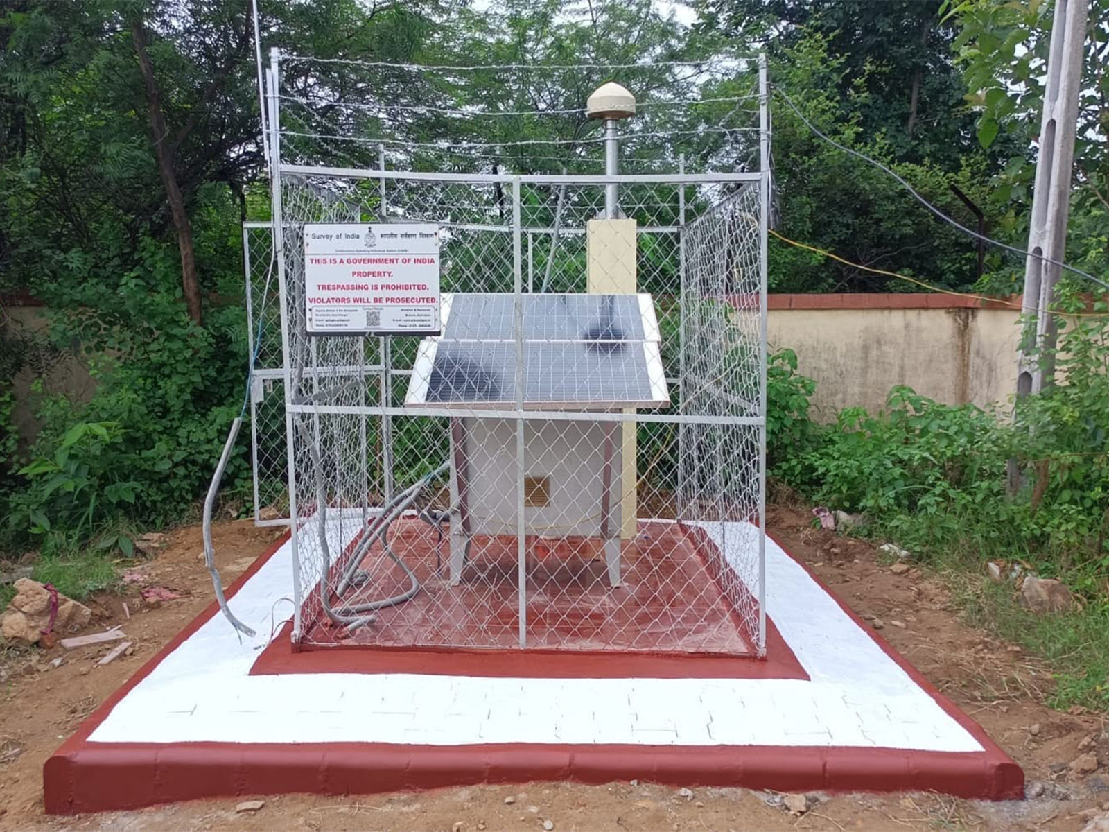
With the objective of connecting traditional mapping practices with the modern digital era, a total of 102 Continuously Operating Reference Stations (CORS) have been established across Gujarat and the Union Territory of Daman and Diu.
These stations provide surveyors, engineers, farmers and drone operators with real-time positioning facilities with centimetre-level accuracy. So far, a total of 1,042 users across Gujarat, Daman and Diu have registered to access this facility. This modern digital infrastructure is also making a significant contribution to building an Aatmanirbhar Bharat.
The vision of Viksit Bharat can be realised only when the benefits of development reach the last person in the country. In this direction, the SVAMITVA Scheme is an important initiative.
As a technical partner under this scheme, the Survey of India has completed the mapping of rural habitation areas in Gujarat and prepared maps of a total of 14,866 villages. This exercise has paved the way for rural households to obtain legal ownership documents for the houses in which they have been residing for generations.
Along with providing clarity and security regarding property ownership, this initiative creates opportunities for accessing loans against property and strengthens the rural economy.
Along the same lines of rural development, accurate mapping support is now also being provided for urban and infrastructure development.
Mapping of the Mumbai-Ahmedabad High-Speed Rail (MAHSR) Corridor is being undertaken for the Town Planning and Valuation Department (TPVD). This corridor is an important project in the direction of modern transportation and infrastructure development in the country.
Similarly, under the AMRUT 2.0 scheme, mapping of 55 cities has been undertaken for the department. The maps being prepared will provide a strong foundation for developing GIS-based Development Plans and Master Plans for these cities. This will enable more scientific and systematic planning for water supply, sewage systems, urban infrastructure and the development of green spaces.
Through these two initiatives, rural and urban development is being integrated with accurate geospatial information. On one hand, property rights in villages are being clearly established, while on the other, a scientific foundation is being created for the future development of cities.
The contribution of the Survey of India is also expanding towards building a clean and reliable energy system. A LiDAR technology-based survey covering an area of 121 square kilometres has been completed at Kakrapar for the Nuclear Power Corporation of India Limited (NPCIL).
This exercise provides the essential geographical foundation for the country's energy security and the planning of critical infrastructure projects. Preparations are underway to undertake surveys across an additional 183 square kilometres in the next phase.
To modernise urban land records, the 'NAKSHA' Project has been implemented jointly by the Department of Land Resources, Government of India, and the Government of Gujarat. Under this project, mapping of five cities has been completed so far.
Through this initiative, efforts are being made to make land and property records in urban areas more accurate, transparent and modern. As a result, urban citizens will also benefit from greater clarity regarding property ownership and reliable documentation.
From the snow-covered peaks of Mount Everest to the vast salt plains of Kutch, the Survey of India has played a historic role in establishing India's geographical identity before the world with scientific precision.
The teams of the Directorate functioning in Gujarat, Daman and Diu are taking this glorious legacy to new heights by using advanced technologies such as drones, LiDAR, GNSS and GIS.
From 1767 to the present day, times have changed, instruments have evolved and technology has undergone revolutionary transformations. However, the fundamental objective of the Survey of India has remained steadfast: to accurately map the country's land, generate reliable geographical information and provide a scientific foundation for the nation's overall development.
Every map, every survey and every piece of geographical information has its own significance in realising the vision of Viksit Bharat @2047. With this firm commitment, the Survey of India continues to be an integral contributor to the country's development journey.
The Survey of India is making an uninterrupted contribution to mapping the nation, empowering citizens and building Viksit Bharat @2047. (ANI)
Mapping Gujarat: Charting the path of development towards Viksit Bharat